Mouth of the Connecticut River
Latitude: 41.254
Longitude: -72.324
Depth: 6.932 m
| Storm | Date | % U max [m s^-1] | %U mean [m s^-1] | % U dir max | % U dir mean | % z(t) max [m] | % sigH maz [m] | % Tpeak max [s] |
| Gloria | Sept. 20, 1985 | 47.369 | 6.515 | 85.797 | 171.531 | 1.357 | 8.035 | 9.675 |
| Sandy | Oct. 25, 2012 | 21.158 | 7.605 | 77.819 | 93.341 | 0.921 | 4.41 | 8.068 |
| NorEaster | Oct. 30, 2012 | 31.881 | 9.278 | 251.152 | 134.012 | 0.972 | 2.572 | 6.729 |
| 1985 | month 9 | 13.375 | 5.356 | 70 | 152.73 | 0.737 | 1.052 | 4.68 |
| 2005 | month 9 | 8.654 | 5.369 | 181.692 | 196.459 | 0.808 | 0.82 | 3.903 |
| 2007 | month 4 | 12.258 | 5.982 | 283.371 | 228.665 | 1.124 | 1.26 | 5.611 |
| 2008 | month 8 | 18.281 | 6.851 | 113.509 | 220.982 | 0.757 | 1.983 | 5.125 |
| 2009 | month 8 | 7.466 | 3.468 | 175.862 | 189.319 | 0.854 | 0.691 | 3.255 |
| 2010 | month 9 | 8.838 | 4.642 | 273.338 | 227.742 | 0.841 | 0.6 | 3.255 |
| 2011 | month 8 | 15.834 | 6.809 | 66.486 | 164.489 | 0.845 | 2.744 | 6.145 |
| 2011 | month 10 | 9.181 | 4.476 | 9.741 | 202.314 | 0.827 | 1.042 | 2.714 |
| 2012 | month 10 | 21.158 | 7.605 | 77.819 | 93.341 | 0.841 | 4.027 | 8.068 |
| 2013 | month 2 | 12.843 | 9.087 | 44.506 | 220.147 | 0.729 | 1.072 | 4.68 |
| 2015 | month 1 | 11.538 | 6.548 | 19.717 | 221.375 | 0.816 | 0.964 | 2.972 |
| 2016 | month 1 | 16.055 | 10.793 | 58.07 | 67.986 | 0.284 | 1.2 | 5.125 |
Attribute Descriptions
| % U max [m s^-1] | maximum wind speed at that point |
| %U mean [m s^-1] | mean wind speed (average over time) |
| % U dir max | maximum wind direction |
| % U dir mean | mean wind direction |
| % z(t) max [m] | maximum sea-surface displacement … storm surge + tides |
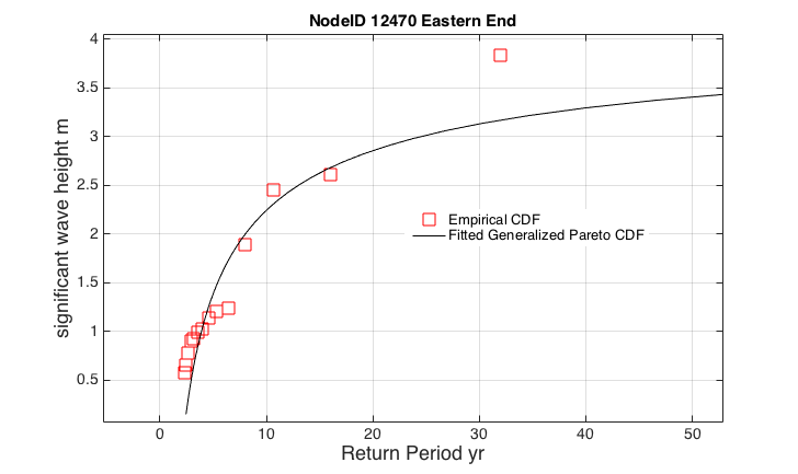
| % sigH max [m] | maximum significant wave height |
| % Tpeak max [s] | maximum dominant wave period |