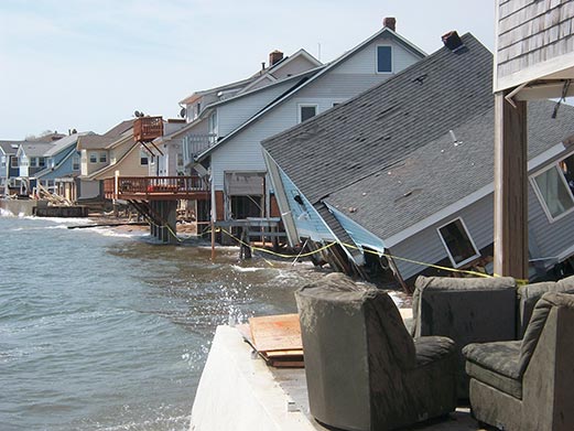
CIRCA has been awarded grants and administered our own grant programs, which involve multiple partners and innovative, resilience planning projects targeting CIRCA's six topic areas: 1) coastal flooding, 2) sea level rise, 3) inland flooding, 4) critical infrastructure, 5) green infrastructure/living shorelines, and 6) policy and planning. Below is a brief description of these projects. Click the Learn More button to read the detailed project description, or use the left navigation choices to search projects by topic area.
CIRCA Research Projects Summary Report 2019
CIRCA Municipal Resilience Grant and Matching Funds Program Summary Report 2019
CIRCA launched the Resilient Connecticut project in fall 2018 and it will run through spring 2023. The project involves extensive public input and coordination with state agencies, regional Councils of Governments and municipalities to develop resilience planning framework and assessments, develop implementation plans, assess flood and heat risk, evaluate adaptation options, and engage stakeholders in New Haven and Fairfield counties to address vulnerabilities to future climate change and sea level rise.

Advancing High Resolution Coastal Forecasting & Living Shorelines Approaches in the Northeast
The Advancing High Resolution Coastal Forecasting and Living Shorelines Approaches in the Northeast advances northeast regional forecasting for inundation from storms under future sea level rise scenarios and identifies policy barriers and potential solutions for the use of living shorelines in the northeast.

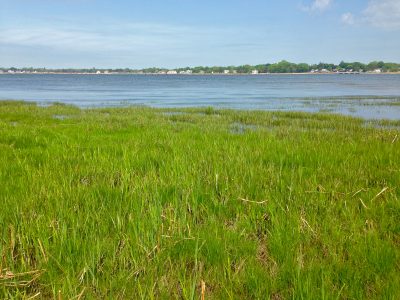
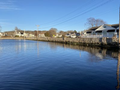
Branford – Jarvis Creek Sea Level & Flooding Variability
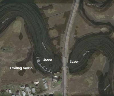
The Jarvis Creek Sea Level and Flooding Variability study in Branford, CT determined how downstream flood prevention activities affect areas upstream in terms of flooding frequency. The Institute provided a report.pdf with policy directions for the DEEP Office of Long Sound Programs for future consideration of similar upstream impacts.
CIRCA/Restore America’s Estuaries Living Shorelines Conference: “Living Shorelines: Sound Science, Innovative Approaches, Connected Community”
On December 1st and 2nd, living shorelines practitioners from around the country met in Hartford, Connecticut for a first-ever national living shorelines summit sponsored by Restore America’s Estuaries and the Connecticut Institute for Resilience and Climate Adaptation (CIRCA). It covered both national and regional landscapes and drew nearly 300 researchers, government employees, engineers, and students.

Clean Water Fund – EASE: Education and Action for Secure Energy
EASE (“Education and Action for Secure Energy”) is a focused program of education and technical assistance to help local decision makers in Connecticut plan for a secure supply of energy in extreme weather and other emergencies and to plan more broadly for local energy security and independence.
Community Rating System (CRS) – Municipal Assistance for FEMA
The Federal Emergency Management Agency (FEMA) administers the National Flood Insurance Program (NFIP) to provide flood insurance within communities that adopt and enforce floodplain regulations. Communities may choose to enter into the National Flood Insurance Program’s Community Rating System (CRS) in order to reduce the cost of flood insurance premiums for their property owners. Communities participating in the CRS Program go above and beyond the minimum standards and, depending on their level of mitigation efforts, can garner insurance premium reductions from 5-45%.

Connecticut Physical Climate Science Assessment Report
Researchers are reviewing the current state of scientific knowledge of recent trends and projections of local climate (temperature and precipitation), with a purpose to inform planning and adaptation by the state, municipalities and local governments, commercial enterprises and NGOs in Connecticut.
![]()
CRCOG – Capitol Region Natural Hazards Mitigation Plan Update
The Capitol Region Council of Governments (CRCOG) was awarded Pre-Disaster Mitigation grant funding from FEMA to update a multi-jurisdictional natural hazard mitigation plan by mid-2019. CIRCA’s Matching Funds award is being used to support the plan update.
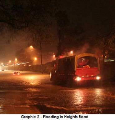
Darien – Low Impact Development for Resilience Against Flooding, Storm Water, and Climate Change
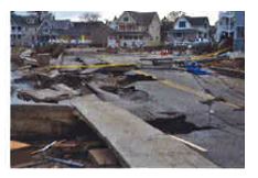
Heights Road in Darien and commercial properties to the north frequently flood due to an undersized stream culvert beneath the road. This flood mitigation project uses principles of Low Impact Development and consists of a combination of flood storage pipes beneath Heights Road and storage and infiltration structures with the fill beneath the nearby train station parking lot.
Demonstrating a Coastal Flood Risk Analysis Framework in Mystic River of Connecticut
Develop a flood risk analysis warning system by integrating atmospheric reanalysis with hydrological and hydraulic models to estimate potential damage and risk under design flood and storm scenario based at coastal areas over Connecticut, specifically parts of the Mystic River and Branford.

Developing Location-Based Communication and Public Engagement Strategies to Build Resilient Coastal Communities
To help reduce the challenges of climate change resilience, this project focuses on providing the tools that could help build socioeconomic resilience and facilitate community support for the planned mitigation projects to benefit the coastal residents and stakeholders in parts of Fairfield and Bridgeport.

Drinking Water Vulnerability Assessment and Resilience Plan
The Connecticut Department of Public Health (DPH) and the Connecticut Institute for Resilience and Climate Adaptation (CIRCA) will work together for the purpose of preparing a Drinking Water Vulnerability Assessment and Resilience Plan to assess, identify, and address vulnerabilities for community water systems in Fairfield, New Haven, New London, and Middlesex counties.
East Lyme – Coastal Resilience, Climate Adaptation, and Sustainability Project
The Town of East Lyme is enhancing community sustainability and resilience to the impacts of climate change, sea level rise, and extreme weather by developing specific policies and recommendations for inclusion in the town’s Plan of Conservation and Development. This project will create a new Flood Ordinance, establish a Flood Commission, and revise local land use policies and regulations.

Fairfield – Benefit Cost Analysis for Climate Resilience
The Town has assessed a recent USACE plan that identified “critical” resilience sections that, if implemented, have the potential to mitigate the majority of the flood damage and impact from major storm events. The Town is hoping to investigate lower cost alternatives to produce a more competitive BCA and then would be able to propose to move those projects forward. CIRCA's MRGP grant covers updated costs and a BCA for two to three sections the town has prioritized as highly beneficial projects.
Fenwick – Hepburn Dune and Marsh Preservation Project
This project implements living shoreline strategies at a site on the coast of Long Island Sound, located just east of the Katherine Hepburn Estate in the Old Saybrook Borough of Fenwick. Left unaddressed, a breach of the existing beach would likely impact the ecology of marsh habitat and infrastructure to surrounding properties. The intent of the Borough is to use a living shoreline (or hybrid) approach, providing both shoreline protection and environmental enhancement.

Financing Resilience in Connecticut: Current Programs, National Models, & New Opportunities
The Financing Resilience in Connecticut: Current Programs, National Models, and New Opportunities literature review and fact sheet provide information on existing resilience financing programs in Connecticut and model programs that can be applied in the State to educate municipalities, regulators, policymakers, and legislators on financing options.
Hartford – Green Infrastructure Specialist for a More Resilient and Sustainable Future
The City of Hartford received grant assistance from CIRCA to hire a Green Infrastructure Specialist for 12 months in support of the city's climate resiliency effort – the Climate Stewardship Initiative (CSI). Through the CSI, Hartford and its collaborators are making strides in five action areas (energy, land, transportation, waste, and water). The Green Infrastructure Specialist will help Hartford respond to threats of flooding while evaluating and advancing green infrastructure projects.
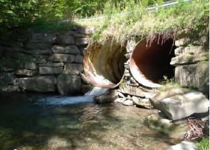
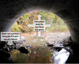
Housatonic Valley Association – Advancing Priority Culvert Right-Sizing Projects in the Naugatuck River Watershed
By the end of 2022, HVA will have completed Road-Stream Crossing Management Plans (RSCMPs) for 14 towns in Connecticut, and 22 towns across the Housatonic watershed. The RSCMPs use information about flood risk, maintenance need and conservation value to collaboratively prioritize culvert replacement projects and recommend culvert design Best Management Practices that reduce flood risk and maintenance costs while restoring habitat connectivity. Watertown, Naugatuck and Beacon Falls is the focus of CIRCA's grant funding and will bring projects to “Shovel-Ready” status.
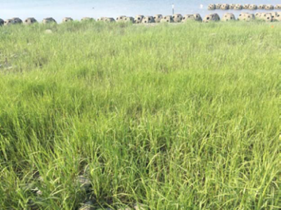
How Will Sea Level Rise-Driven Shifts in Wetland Vegetation Alter Ecosystem Services?
This project examines how sea level rise (SLR) induced shifts in vegetation will change ecosystem services provided by Long Island Sound (LIS) coastal wetlands. Specifically, the project will: 1) quantify the delivery of ecosystem services associated with dominant tidal wetland plant species of the LIS; 2) examine impacts of SLR and interactions; 3) forecast how shifts in dominant tidal wetland species will alter ecosystem service provision of LIS coastal wetlands; and 4) promote understanding of the complex interactions among SLR, coastal wetlands, and ecosystem services among diverse audiences in the LIS region.
Increasing Resilience and Reducing Risk Through Successful Application of Nature Based Coastal Infrastructure Practices in New England
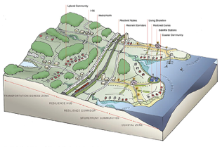
Since the State of Connecticut has adopted regulations to limit further expansion of hard coastal protection structures (sea walls, revetments etc.) and to promote the use of “living shore line” approaches, tracking the effectiveness of demonstration sites is a priority activity. As a consequence of its geological setting and development history, the harbors of Connecticut require periodic maintenance dredging to ensure safe navigation.

Kent Land Trust – Creation of a Strategic Workplan to Identify Parcels Enhancing Climate Resilience
The Kent Land Trust was established in 1989 to preserve natural resources in Kent and surrounding areas through land protection, stewardship, public outreach, education, and research. The primary goal of their CIRCA Matching Fund project was to develop a more science-based climate-focused land acquisition and land management strategy. The new model strikes a balance between cultural, historic, and aesthetic considerations and natural resource criteria linked to climate resilience.
![]()
MetroCOG – Beardsley Zoo Green Infrastructure Project
The Connecticut Metropolitan Council of Governments (MetroCOG), received a CIRCA grant award for a “Beardsley Zoo Green Infrastructure Project”, which is a highly visible green infrastructure retrofit project at the zoo located along the Pequonnock River in Bridgeport. This collaborative project between MetroCOG, the Beardsley Zoo, the Connecticut Fund for the Environment, and its bi-state program Save the Sound will build on regional resilience planning efforts and the successful completion of a green infrastructure demonstration project at the Zoo. CIRCA’s funding for the project is supporting installation and outreach efforts including signage and workshops.
MetroCOG – Designing Resilience: Living Shorelines for Bridgeport
The Connecticut Metropolitan Council of Governments (MetroCOG), in partnership with the City of Bridgeport and The Nature Conservancy (TNC) is developing design plans for a living shoreline project at Bridgeport’s West Johnson Creek. This project will advance design concepts from the Regional Framework for Coastal Resilience in Southern Connecticut, which supported the development of conceptual designs for coastal resiliency/living shoreline projects identified as “high priority” by local stakeholders. Construction-ready plans funded through this round of CIRCA’s Municipal Resilience Grant Program will position the Bridgeport project for future implementation.
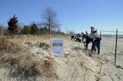
Milford – Developing and Implementing a Restoration and Management Plan to Combat Threats and Challenges to Coastal Dune Resiliency in Urban Landscapes
With 17.5 miles of coast, the City of Milford has the longest shoreline in Connecticut, which was severely impacted in both storms Irene and Sandy. This project is implementing best practices to restore the now degraded sand dune in a high traffic, urban beach community while developing a plan for post-restoration management of the restored dune.
Municipal Resilience Planning Assistance for Sea Level Rise, Coastal Flooding, Wastewater Treatment Infrastructure, & Policy
The Municipal Resilience Planning Assistance for Sea Level Rise, Coastal Flooding, Wastewater Treatment Infrastructure, and Policy project provides information for wastewater system vulnerability assessments, combined river and coastal flooding for pilot sites, and policy options for priority resilience projects for towns in the Sandy-impacted counties.
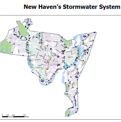
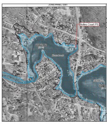
New Haven – Assessing Impacts of Tides and Precipitation on Downtown Storm Sewer System Through Use of Real-Time Depth and Flow Monitoring
New Haven experiences frequent flooding at several locations crucial to the functioning of the City and regional transportation systems during high intensity, short duration rainfall events. This project creates a low-cost “smart city” stormwater sensor network to provide a detailed record of the interaction of rainfall, tides, green stormwater infrastructure, and sewer conveyance systems on the hydrology of New Haven’s urban core. A better understanding of system response during a range of hydrologic conditions will allow the City to value engineer cost-effective and resilient solutions.
New Haven Industrial Toolbox
Flooding events can cause closures in New Haven’s commercial downtown area. In response, City officials organized the Program for Public Information in 2014 and formed a committee that was charged with making recommendations to help address flooding issues. One recommendation of the committee was to create and implement a New Haven Commercial Industrial Toolbox (CIT) to enhance resilience of the city’s commercial infrastructure by creating a manual to assist commercial property owners before flooding events occur.
New London – Bank Street – South Water Street Project
This project is located between Bank Street and South Water Street in New London, Connecticut. It is a community-based resiliency plan focused on sea level rise. Situated on the Thames River and Long Island Sound, the city of New London has been historically vulnerable to flooding, and sea level rise projections depict even worse scenarios. This project works with the city’s Mayor’s Office and the Business Owners Association to develop a science-based design to mitigate negative impacts of sea level rise while spurring economic growth along South Water Street.
NHCOG – Building Municipal Resilience & Climate Adaptation Through Low Impact Development
With flooding, erosion, and sedimentation becoming an increasing concern for Northwest Connecticut towns, the Northwest Conservation District supported by Northwest Hills Council of Governments staff, coordinated the creation of a Low Impact Sustainable Development (LISD) Design Manual. The manual, designed for the town of Morris Planning & Zoning Commission, describes the need for an LID approach, engineering specifications for successful systems, and sample enforcement tools.
![]()
NHCOG – Enhancing Rural Resiliency: A Vision and Toolkit for Adaptation in the Northwest Hills
As a region of 21-towns, the Northwest Hills will experience a variety of climate changes including changes to precipitation rates, increased high heat and high-ozone days, and extreme weather events. NHCOG received a CIRCA grant award for its project, “Enhancing Rural Resiliency: A Vision and Toolkit for Adaptation in the Northwest Hills.” NHCOG and regional partners will use CIRCA’s support to craft a vision for A Resilient Northwest Hills and produce a web-hosted climate change adaptation toolkit for municipalities.
Northwest Conservation District – Building Municipal Resilience Using Low Impact Development Design
Northwest Conservation District (NCD) is working in partnership with CIRCA and the Northwest Hills COG to develop a model Low Impact Development (LID) Design Manual.
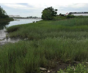
Norwalk Land Trust – The Village Creek Saltmarsh Restoration Demonstration
The Norwalk Land Trust, in conjunction with the Village Creek Harbor Corporation, engaged the services of the environmental engineering firm Fuss & O’Neill to study the feasibility of restoring the saltmarsh in the Village Creek Estuary in Norwalk, CT. The broad objective was to determine the feasibility of restoring the degraded saltmarshes with dredged materials from the established Village Creek small-boat harbor situated within the estuary.
Oxford – Planning for Flood Resilient and Fish-Friendly Road-Stream Crossings in the Southern Naugatuck Valley
The Town of Oxford in partnership with Town of Seymour, Housatonic Valley Association (HVA), UConn/CIRCA researchers, and Princeton Hydro LLC are working to reduce flood damage risk and improve river and stream habitat connectivity in the lower Naugatuck Valley by integrating climate change resilience into the management of road-stream crossings. Through this project the towns are developing a road-stream crossing inventory and a management plan.
Old Saybrook – Back River Living Shoreline Design
Back River is a natural tidal marsh channel, hydraulically connecting marsh to Long Island Sound. Upstream and downstream of a Rte 154, the river bends sharply to the north and continues to meander throughout the marsh. The bridge restrains the natural meander of the channel and also result in high velocity flow and eddies and whirlpools, which contribute to erosion of bank edges, loss of marsh area and deep channel scour holes. CIRCA funds will help explore a living shoreline to mitigate impacts to the marsh and channel, providing both ecological and shoreline protection benefits.
Public Support for Adaptation to Sea Level Rise
The Public Support for Adaptation to Sea Level Rise project will survey Connecticut coastal residents to examine their preferences and values with respect to various measures to preserve coastal areas and resources in the face of sea level rise.

Real Estate Values, Tax Revenues, and Climate Change-Induced Retreat from Flood Zones
What is the cost of preserving, maintaining, or restoring coast-front (vulnerable) properties? This proposal outlines an approach to ascertain the value of oceanfront status for homes located near the coast.
Real‐time Flood Prediction & Vulnerability Analysis of Connecticut’s Inland River Network
The Real‐time Flood Prediction and Vulnerability Analysis of Connecticut’s Inland River Network project provides a hydrology model for Connecticut’s rivers and applies this model to determine flood vulnerabilities in current and future climate scenarios.
Resilient Coastal Communities under Wind & Flood Hazards
The Resilient Coastal Communities under Wind and Flood Hazards project will evaluate and compare trade-offs in residential home building designs to reduce risk of wind and flood damage in order to reduce coastal community vulnerabilities. The towns of Fairfield and Milford are participating in the study.
Restored vs. Natural Living Shorelines: Comparison of Ecosystem Services, Erosion Control, and Habitat Use
This project questions- “Do living shorelines provide similar ecosystem services to naturally established estuarine habitats in Connecticut?” A recently established living shoreline in Stratford, CT provides a unique opportunity to compare the ecosystem services of two newly planted saltmarshes to nearby established marshes in the same estuary of the Housatonic River.
RiverCOG – Regional Long Term Recovery-Land Use Resiliency Plan
The RiverCOG developed a Regional Long Term Recovery and Land Use Mitigation Plan for its 17 towns based on real-time data and forecasts, mapping, and best management engineering practices for infrastructure (transportation, water, wastewater, utilities) as they relate to resilience in land use policies and climate adaptation. The Plan creates a template for towns to incorporate land use and infrastructure policies that will improve resiliency from natural hazard events and a strategy for long term recovery efforts.
Road Flooding in Coastal Connecticut
The coastline of Connecticut is characterized by numerous inlets where the rivers and streams carrying runoff from land towards the ocean and the saline tidal waters of Long Island Sound intrude into the channels.
SAFR Connecticut Connections Vulnerability Assessment & Resilience Concept – National Disaster Resilience Competition (NDRC)
The SAFR Connecticut Connections Vulnerability Assessment and Resilience Concept – National Disaster Resilience Competition (NDRC) developed a climate change and extreme weather vulnerability assessment for the coasts of New Haven and Fairfield counties and a resilience concept for using the natural high ridgelines of Connecticut to connect low-lying coastal communities to resilient transit-oriented development along Metro North.
Scoping of Dredge Material Islands & Wetlands for Green Infrastructure Resiliency
The Scoping of Dredge Material Islands and Wetlands for Green Infrastructure Resiliency Projects Along the Connecticut Shoreline in Fairfield and New Haven Counties project will provide design guidelines and a regulatory framework for creating wetlands from dredge materials in Connecticut to increase shoreline resiliency.
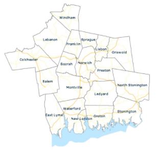
SCCOG – Southeastern Connecticut Critical Facilities Assessment
SCCOG conducted an assessment of 18 community facilities located in or near flood zones that are critical for ongoing public services, including fire and police stations, town halls, and departments of public works. The assessment identifies risks to these properties and service continuation from flooding, wind damage, and snow loads now and over the next several decades. For each site, the assessment recommends appropriate flood prevention measures, potentially including relocation, site modifications such as flood walls, flood proofing, and elevation of utilities.

SCCOG – Stormwater Authority Pilot Project
The Southeastern Connecticut Council of Governments (SCCOG) is starting a pilot program to help municipalities take steps to implement stormwater authorities. SCCOG hired a consultant, CDM Smith, to lead the Stormwater Authority Pilot Program that assists four municipalities with accomplishing prerequisite steps toward establishing stormwater utilities and identifies future steps and department roles and responsibilities for implementation. Stonington, Waterford, Ledyard, and Preston are all participating in the project.
SCRCOG- Climate Adaptation and Resiliency Planning for Protection of Public Drinking Water
UConn researchers are working with the South Central Regional Council of Governments (SCRCOG) and the South Central Connecticut Regional Water Authority (RWA) to integrate climate change information into water planning processes for the region. With changing precipitation patterns, sea level rise, and drought anticipated due to climate change, water resource managers will benefit from integration of climate data into planning.
SCRCOG – Design and Technical Guide for Implementing Innovative Municipal Scale Coastal Resilience in Southern Connecticut
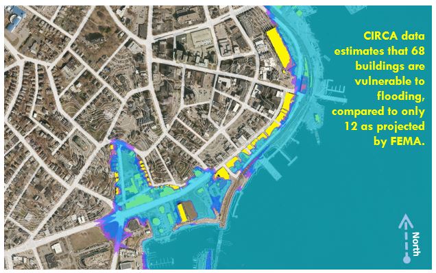
Coastal adaptation and resilience planning at the municipal scale faces multiple challenges including concerns with the tax base, lack of decision support tools, and gaps in valuing urban ecosystem services. A project team consisting of Yale researchers, the South Central Regional Council of Governance (SCRCOG) staff, and municipal officials seek to overcome challenges that practitioners, planners, and policymaker’s encounter by using coastal adaptation strategies applied to projects in Old Field Creek in West Haven and Cosey Beach in East Haven.
Stamford – Resilience Opportunity Assessment
The City of Stamford’s “Resilience Opportunity Assessment” is a pilot project reviewing potential vulnerability to climate change hazards at Stamford’s Government Center and High School. Government Center is where the majority of City operations are housed and the school is one of several locations serving as a public emergency shelter during blackouts and storms. This pilot assessment not only provides an opportunity to advance resiliency in specific municipal buildings, but is an opportunity to improve how the entire City functions and recovers from possible disaster.
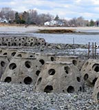
Stratford Point Living Shoreline: Restoring Coastal Habitats to Maintain Resiliency and Function
Led by researchers at Sacred Heart University, this project expands an existing living shoreline project at Stratford Point, Fairfield County, Connecticut. On-going coastal restoration efforts and research at the site consist of an artificial reef, smooth cordgrass (Spartina alterniflora) marsh, high marsh, coastal dune and upland woody/grassland mosaics.
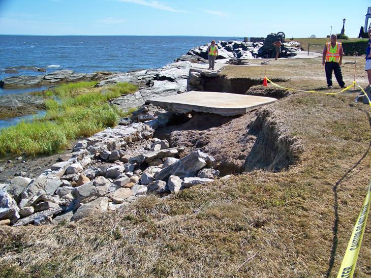
Stonington – Holmes Street Resilient Seawall Design
The Holmes Street Seawall foundation in Stonington has been eroding significantly under increased water-level rising and severe weather events. Building sustainable resilient infrastructure is key to preserving the area and linkages between the important regional economic drivers of downtown Mystic and the Mystic Seaport. Replacing this seawall can be made into an example of resilience for the Town of Stonington and other communities addressing infrastructure impacts from increasing storm surge and sea level rise.
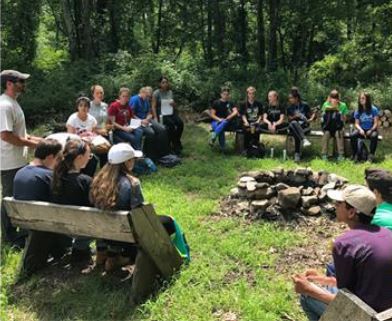
University of Connecticut – Natural Resources Conservation Academy: Fostering Young Scientists in Connecticut Communities
The Natural Resources Conservation Academy’s mission is to provide transformative and authentic learning opportunities to diverse groups of high school students; stimulating critical thinking, creativity, decision-making, and appreciation of science application and nature while contributing to local environmental solutions. The NRCA directly educates high school students from throughout the state each year on climate change effects in Connecticut as well as solutions to climate change issues. All NRCA student conservation projects are conducted in both coastal and inland communities and a majority of projects address adaptation or mitigation solutions to climate change. Student conservation projects also often include an educational component, in which the student’s community will learn about the climate change issue that the student’s project is addressing and possible solutions. NRCA will advance the development of resilience and sustainability of coastal and inland communities that are vulnerable to the impacts of climate change.
Waterford Municipal Infrastructure Resilience Project
The Waterford Municipal Infrastructure Resilience Project is a two-part project that assesses the vulnerabilities of the town’s sewer pumps stations as well as an analysis of drainage at Gardiners Wood Road. The flooding Waterford has been receiving during recent storms has caused disruptions to multiple pump stations, demonstrating the need for repairs. The pump stations evaluated are on the border, or within areas noted as having a high probability of inundation under certain sea level rise scenarios.
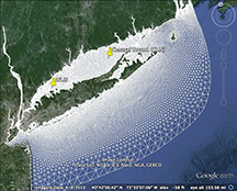
Waves in Long Island Sound and Living Shorelines Site Suitability Tool: NOAA CREST project
The NOAA CREST project has significant wave heights for different return periods for all of Long Island Sound, measurements of waves in Old Saybrook and New Haven harbors, a review of design guidelines and tools for site assessment of living shorelines. This information is summarized in an online map viewer.
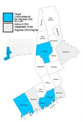
WestCOG – Regional CRS Program
Western Connecticut is extremely vulnerable to natural hazards. Many of its most critical assets including public safety, sanitation facilities, transportation corridors, employment centers, and affordable housing are located on or near the coast or the region’s many inland waterways. Using a CIRCA grant, WCOG is taking steps to create a regional CRS program and specifically assist four municipalities as they take on mitigation efforts to reduce the impacts of coastal and riverine flooding. WCOG is helping to provide cost savings by performing CRS activities and CRS municipal coordination at a regional scale.