Project Summary
This project is located between Bank Street and South Water Street in New London, Connecticut. It is a community-based resiliency plan focused on sea level rise. Situated on the Thames River and Long Island Sound, the city of New London has been historically vulnerable to flooding, and sea level rise projections depict even worse scenarios. This project works with the city’s Mayor’s Office and the Business Owners Association to develop a science-based design to mitigate negative impacts of sea level rise while spurring economic growth along South Water Street.
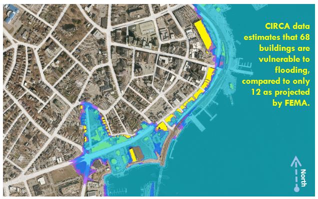
The project has used sea level rise projections developed by the Connecticut Institute for Resilience & Climate Adaptation (CIRCA), referenced by the recently introduced state-wide legislation on Climate Change Planning and Resiliency (Public Act 18-82), to communicate the potential impacts of rising waters to the local community. This science guided approach began with the creation of three different design strategies. These were then presented to local officials and property owners to discuss potential solutions that would ensure a sustainable future for their community. Based on public input, designs were then revised, and a new meeting was held to ensure that multiple options were explored. The meetings were held to stimulate conversation with stakeholders, to ensure that consensus on a design was obtained, but also that concerns were expressed so that the proposed strategies aligned with the community’s vision for the future.
Product
Project Team
- Peter Miniutti - UConn, Department of Plant Science and Landscape Architecture
- Miriah Kelly – UConn, Evaluation and Public Engagement
- Natalie Miniutti – UConn, Architecture and Community Planning
- Mariana A. Fragomeni – UConn, Climate Planning and Design (PhD Candidate)
- Tao Wu – UConn, Sea Level Rise and Flood Mitigation Design (PhD Student)