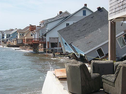
 Coastal Flooding & Waves
Projects Related to Coastal Flooding and Waves
CIRCA works to enhance coastal resilience to coastal flooding and waves in Connecticut. Coastal flooding is caused by waves, storm surge, and high tide, particularly with increased sea levels. In coastal areas where there are also rivers, rainfall contributes to coastal flooding as well. Waves also contribute to shoreline erosion and information on waves is important for designing living shorelines.
Below is a brief summary description of our current Coastal Flooding and Waves projects. Click the Learn More button to read the detailed project description, or use the left navigation.

Advancing High Resolution Coastal Forecasting & Living Shorelines Approaches in the Northeast
The Advancing High Resolution Coastal Forecasting and Living Shorelines Approaches in the Northeast advances northeast regional forecasting for inundation from storms under future sea level rise scenarios and identifies policy barriers and potential solutions for the use of living shorelines in the northeast.

Branford – Jarvis Creek Sea Level & Flooding Variability
The Jarvis Creek Sea Level and Flooding Variability study in Branford, CT determined how downstream flood prevention activities affect areas upstream in terms of flooding frequency. The Institute provided a report.pdf with policy directions for the DEEP Office of Long Sound Programs for future consideration of similar upstream impacts.
Community Rating System (CRS) – Municipal Assistance for FEMA
The Federal Emergency Management Agency (FEMA) administers the National Flood Insurance Program (NFIP) to provide flood insurance within communities that adopt and enforce floodplain regulations. Communities may choose to enter into the National Flood Insurance Program’s Community Rating System (CRS) in order to reduce the cost of flood insurance premiums for their property owners. Communities participating in the CRS Program go above and beyond the minimum standards and, depending on their level of mitigation efforts, can garner insurance premium reductions from 5-45%.
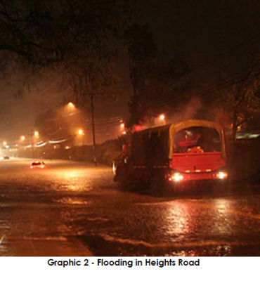
Darien – Low Impact Development for Resilience Against Flooding, Storm Water, and Climate Change
Heights Road in Darien and commercial properties to the north frequently flood due to an undersized stream culvert beneath the road. This flood mitigation project uses principles of Low Impact Development and consists of a combination of flood storage pipes beneath Heights Road and storage and infiltration structures with the fill beneath the nearby train station parking lot.

Demonstrating a Coastal Flood Risk Analysis Framework in Mystic River of Connecticut
Develop a flood risk analysis warning system by integrating atmospheric reanalysis with hydrological and hydraulic models to estimate potential damage and risk under design flood and storm scenario based at coastal areas over Connecticut, specifically parts of the Mystic River and Branford.
East Lyme – Coastal Resilience, Climate Adaptation, and Sustainability Project
The Town of East Lyme is enhancing community sustainability and resilience to the impacts of climate change, sea level rise, and extreme weather by developing specific policies and recommendations for inclusion in the town’s Plan of Conservation and Development. This project will create a new Flood Ordinance, establish a Flood Commission, and revise local land use policies and regulations.
How Will Sea Level Rise-Driven Shifts in Wetland Vegetation Alter Ecosystem Services?
This project examines how sea level rise (SLR) induced shifts in vegetation will change ecosystem services provided by Long Island Sound (LIS) coastal wetlands. Specifically, the project will: 1) quantify the delivery of ecosystem services associated with dominant tidal wetland plant species of the LIS; 2) examine impacts of SLR and interactions; 3) forecast how shifts in dominant tidal wetland species will alter ecosystem service provision of LIS coastal wetlands; and 4) promote understanding of the complex interactions among SLR, coastal wetlands, and ecosystem services among diverse audiences in the LIS region.
Municipal Resilience Planning Assistance for Sea Level Rise, Coastal Flooding, Wastewater Treatment Infrastructure, & Policy
The Municipal Resilience Planning Assistance for Sea Level Rise, Coastal Flooding, Wastewater Treatment Infrastructure, and Policy project provides information for wastewater system vulnerability assessments, combined river and coastal flooding for pilot sites, and policy options for priority resilience projects for towns in the Sandy-impacted counties.
New London – Bank Street – South Water Street Project
This project is located between Bank Street and South Water Street in New London, Connecticut. It is a community-based resiliency plan focused on sea level rise. Situated on the Thames River and Long Island Sound, the city of New London has been historically vulnerable to flooding, and sea level rise projections depict even worse scenarios. This project works with the city’s Mayor’s Office and the Business Owners Association to develop a science-based design to mitigate negative impacts of sea level rise while spurring economic growth along South Water Street.
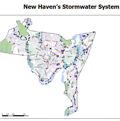
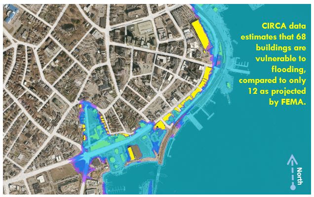
New Haven – Assessing Impacts of Tides and Precipitation on Downtown Storm Sewer System
New Haven experiences frequent flooding at several locations crucial to the functioning of the City and regional transportation systems during high intensity, short duration rainfall events. This project creates a low-cost “smart city” stormwater sensor network to provide a detailed record of the interaction of rainfall, tides, green stormwater infrastructure, and sewer conveyance systems on the hydrology of New Haven’s urban core. A better understanding of system response during a range of hydrologic conditions will allow the City to value engineer cost-effective and resilient solutions.
Resilient Coastal Communities Under Wind & Flood Hazards
The Resilient Coastal Communities under Wind and Flood Hazards project will evaluate and compare trade-offs in residential home building designs to reduce risk of wind and flood damage in order to reduce coastal community vulnerabilities. The towns of Fairfield and Milford are participating in the study.
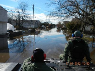
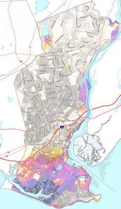
Road Flooding in Coastal Connecticut
The coastline of Connecticut is characterized by numerous inlets where the rivers and streams carrying runoff from land towards the ocean and the saline tidal waters of Long Island Sound intrude into the channels.
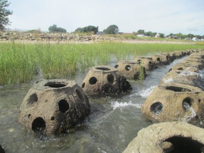
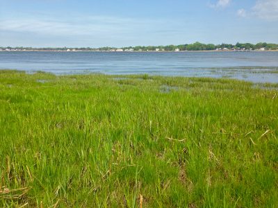
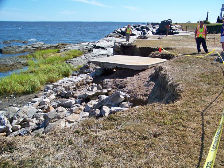
Stratford Point Living Shoreline: Restoring Coastal Habitats to Maintain Resiliency and Function
Led by researchers at Sacred Heart University, this project expands an existing living shoreline project at Stratford Point, Fairfield County, Connecticut. On-going coastal restoration efforts and research at the site consist of an artificial reef, smooth cordgrass (Spartina alterniflora) marsh, high marsh, coastal dune and upland woody/grassland mosaics.
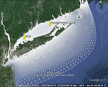
Waves in Long Island Sound and Living Shorelines Site Suitability Tool: NOAA CREST Project
The NOAA CREST project has significant wave heights for different return periods for all of Long Island Sound, measurements of waves in Old Saybrook and New Haven harbors, a review of design guidelines and tools for site assessment of living shorelines. This information is summarized in an online map viewer.
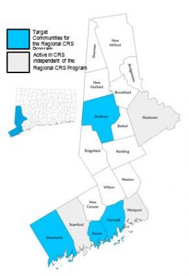
WestCOG – Regional CRS Program
Western Connecticut is extremely vulnerable to natural hazards. Many of its most critical assets including public safety, sanitation facilities, transportation corridors, employment centers, and affordable housing are located on or near the coast or the region’s many inland waterways. Using a CIRCA grant, WCOG is taking steps to create a regional CRS program and specifically assist four municipalities as they take on mitigation efforts to reduce the impacts of coastal and riverine flooding. WCOG is helping to provide cost savings by performing CRS activities and CRS municipal coordination at a regional scale.