Municipal Resilience Planning Assistance

About the Project

The “Municipal Resilience Planning Assistance Project” combined science, policy, and planning at the state and local levels to address the resilience of vulnerable communities along Connecticut’s coast and inland waterways to the growing impacts of climate change. The purpose of the project was to develop tools for municipalities to assess vulnerable infrastructure to inundation by river flow, sea level rise, and storm surge in the next 25-50 years.  This work was made possible through a Municipal Resilience Planning Assistance grant from the State of Connecticut Department of Housing CDBG-Disaster Recovery Program and the US Department of Housing and Urban Development

An public event entitled, Creating a Resilient Connecticut: A CIRCA Forum on Science, Planning, Policy & Law was held in May 2018 to provide information through presentations and posters.  A recording of the event includes a welcome by CT DEEP Commissioner Rob Klee announcing news of recent climate legislation and a keynote address by Harriet Tregoning entitled, “Connecticut’s Future in a Disaster-Prone World”.

CIRCA partnered with CT DEEP, UConn faculty, CLEAR, and CT Sea Grant to develop information and tools for this project organized under the following topics: 1) sea level rise and coastal flooding, 2) inland flooding, 3) critical infrastructure, and 4) policy and planning.  Boxes on the right feature some of the important products from this work.

report icon

TOOLS

Sea Level Rise Projections for Connecticut

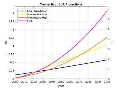
CIRCA recommends that Connecticut plan for the upper end of the range of values projected of sea level rise or up to 20 inches (50cm) of sea level rise higher than the national tidal datum in Long Island Sound by 2050 and that it is likely that sea level will continue to rise after that date.

Learn More

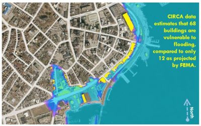
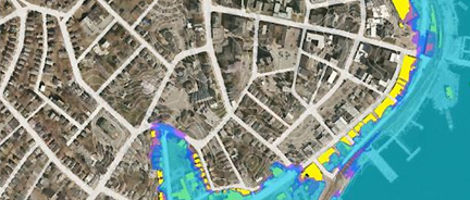
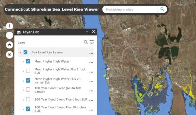
Connecticut Sea Level Rise and Storm Surge Map Viewer

CIRCA's new map viewer shows different sea level rise projections (1 foot and 20 inches), above a Mean Higher High Water (MHHW) to illustrate that planning should anticipate up to 20 inches of sea level rise by 2050 along the Connecticut coastline and adjacent inland. CIRCA’s report on Connecticut sea level rise provided the basis for these projections.

Learn More

Additional Tools

  • 2016 Aerial Infrared Photography : aerial photography is an effective tool for monitoring and assessing the natural and man-made features of the Connecticut shoreline. CT DEEP's Land and Water Resources Division utilizes aerial photographs in regulatory, land use planning, and resource management activities and has conducted coastal aerial photo flights at roughly 5 year intervals since 1974. Updated in 2016 aerial photos can be found online through CT ECO.
  • Online Enhanced Tidal Wetland Layer (search for "CT Wetlands"): an inventory of data for estuarine, marine and freshwater emergent tidal wetlands compared with 2016 aerial photography
  • New Planning and Visualization Tools for Sea Level Rise
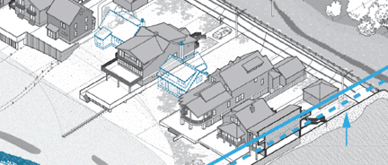
    Barrier Beach Diagram

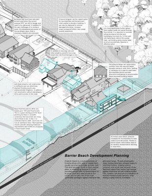
    Marsh Resilience Diagram

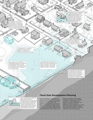
    Resilience Corridor Diagram

report icon

REFERENCES

Sea Level Rise Public Meeting Materials - October 19, 2017: The public meeting included a 30-minute presentation, explaining the Executive Summary report (below). The webinar recording provides a more in-depth explanation of analyses and conclusions.

Sea Level Policy White Papers – Released by CIRCA and UConn's Center for Energy and Environmental Law

    report icon

    TOOLS

    Connecticut River Flow Viewer

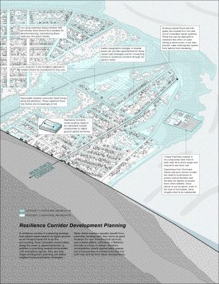
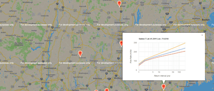
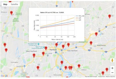
    This map viewer shows the entire Connecticut river network where points can be clicked on to display graphs showing the 100 and 200 year return period volumetric flow rates.

    report icon

    REFERENCES

    Municipal Issues & Needs for Addressing Climate Adaptation in Connecticut
    Authored by:

    Bruce Hyde, UConn Center for Land Use Education and Research and UConn Extension
    Juliana Barrett, Connecticut Sea Grant College Program and UConn Extension

    Law & Policy White Paper Series  - Released by CIRCA and UConn's Center for Energy and Environmental Law (CEEL)

    2018 Connecticut Sea Level Rise Legislation

    CIRCA's report, Sea Level Rise and Coastal Flood Risk in Connecticut published in 2018 provides the basis for sea level rise projections in Governor's Bill S.B. 7, which was introduced into the 2018 legislative session and was enacted into law as Public Act 18-82.

    Senate Bill No. 7, Public Act No. 18-82 - AN ACT CONCERNING CLIMATE CHANGE PLANNING AND RESILIENCY. PA 18-82

    Substitute Senate Bill No. 9, Public Act No. 18-50 - AN ACT CONCERNING CONNECTICUT’S ENERGY FUTURE. PA 18-50

      map image

      FEATURED TOOL

      Sea Level Rise Projections

      MAP VIEWER

      FINAL REPORT

      map image

      FEATURED TOOL

      River Flow Rates Map Viewer

      Interactive graphs of return interval for flow rates on Connecticut river networks

      RIVER FLOW MAP VIEWER

      map image

      Featured Reference

      Municipal Issues & Needs for Addressing Climate Adaptation in Connecticut

      FINAL REPORT

      map image

      Featured Reference

      New London Case Study

      UConn landscape architecture team develops models for coastal resilience along historic waterfront

      READ ARTICLE

      FINAL REPORT

      map image

      Featured Reference

      Visualization Tools for
      Sea Level Rise

      Three resilience scenarios or drawings for communication and planning that depict sea level rise and flooding problems common in many coastal towns.

      LEARN MORE

      Researchers & Staff Support

      James O’Donnell, UConn, Marine Sciences, UConn CIRCA

      Emmanouil Anagnostou, UConn, Civil & Environmental Engineering

      Christine Kirchhoff, UConn, Civil & Environmental Engineering

      Amy Burnicki, UConn Civil & Environmental Engineering

      Joe MacDougald, UConn Law School, Center for Energy and Environmental Law

      William Rath, CEEL, UConn School of Law

      Juliana Barrett, Extension, CT Sea Grant, UConn CLEAR

      Bruce Hyde, Extension, UConn CLEAR

      Peter Minutti, UConn NRE

      DeAva Lambert, CT DEEP

      Rebecca A French, UConn CIRCA

      Katie Lund, UConn CIRCA


      Funding

      Work was made possible through a Municipal Resilience Planning Assistance grant from the State of Connecticut Department of Housing CDBG-Disaster Recovery Program and the US Department of Housing and Urban Development