Project Summary
UConn CIRCA performed an assessment of the effects of engineered tidal flow constrictions on the variability of the sea level in salt marshes and the frequency of flooding in upstream areas, focused on Jarvis Creek (Branford).
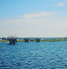
The Town of Branford, CT, and the Branford Land Trust have reported that high water levels at Jarvis Creek Marsh, CT, have led to flooding on Leetes Island Road (RT 146) and at a field adjacent to the marsh. Exchange of water between Long Island Sound and the marsh complex is currently influenced by a tide gate and a berm at the southern end of marsh and a railway bridge that crosses the middle of the marsh. The berm had been modified by the Land Trust with funds from a grant from the Connecticut Department of Energy and Environmental Protection as part of a marsh restoration program and to improve public access. This report describes observation and the development of a mathematical model that quantitatively assesses the influence of the tide gate and the berm on the exchange with Long Island Sound and the frequency of flooding.
Product
Jarvis Creek Flooding Study_ReportFinal_29Aug2016
Researchers and Staff Supported on Project
- James O’Donnell, UConn Marine Sciences
- Michael Whitney, UConn Marine Sciences
- Kay Howard-Strobel, UConn Marine Sciences
- Christina Menniti, Graduate Student, UConn Marine Sciences
Jarvis Creek

Long Island Sound