Project Summary
The Town of Oxford in partnership with Town of Seymour, Housatonic Valley Association (HVA), UConn/CIRCA researchers, and Princeton Hydro LLC worked on a project to reduce flood damage risk and improve river and stream habitat connectivity in the lower Naugatuck Valley by integrating climate change resilience into the management of road-stream crossings. In both towns, road-stream crossings are highly vulnerable to floods as well as potential areas for conservation-oriented development. The towns are working with several partners to identify priority crossings, in order to target their future mitigation efforts. Oxford and Seymour are developing pre-replacement plans for structures most at-risk, and prioritized based on flood damage risk, crossing condition, maintenance need, and habitat restoration value. Through this CIRCA funded municipal grant project, the towns developed road-stream crossing inventories and management plans. This Municipal Resilience Grant award was for the amount of $33,660.
Products
Oxford HVA Final CIRCA Grant Report
Oxford and Seymour Management Plans/associated materials
Project Description
Road-stream crossings (bridges and culverts) are structures designed to carry a road over a stream. Undersized and/or misaligned road-stream crossings are more vulnerable to flood damage and can also be barriers to fish and wildlife movement. This project increases the climate resilience of two communities who have already been affected by extreme storm events and who remain vulnerable to future flooding.
Analysis lays the groundwork for Oxford and Seymour to investigate culvert replacement in terms of both flood resilience and habitat connectivity. By focusing on the resilience of road/stream crossings, these communities can identify and address priorities that reduce flood risks and maintain the integrity of their transportation network. The resulting Road/Stream Crossing Inventories and Management Plans are tools to help these communities adapt to a changing climate and future storms and serve as a model for other towns dealing with similar issues. These planning documents will also be adopted as part of each town’s Natural Hazard Mitigation Plan.
Project Team Members
Michael Jastremski, Lindsay Keener-Eck, and Courteny Morehouse - Housatonic Valley Association
Paul Woodworth - Princeton Hydro LLC
Emmanouil Anagnostou – UConn, Civil & Environmental Engineering
Kathleen O'Neil - Town of Oxford
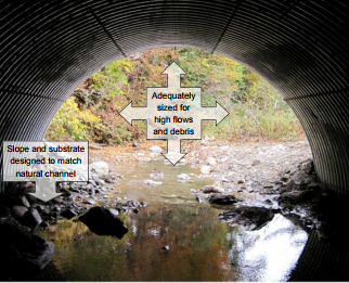
Stream Simulation Design is a method for developing crossings that mimic the natural stream channel through a structure, as if the crossing didn’t exist.
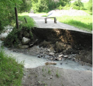
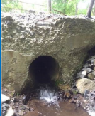
Undersized and/ormisaligned road-stream crossings are more vulnerable to flood damage and can be barriers to fish and wildlife movement.
More rain and larger floods mean more structures are undersized, and also increase pollution from stormwater runoff and stream instability; warming waters mean less habitat for cold-water obligate species.
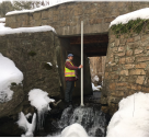
Data was collected from structures such as this.