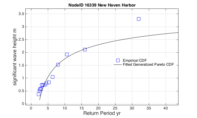
New Haven Harbor
Latitude: 41.232
Longitude: -72.918
Depth: 6.244 m
| Storm | Date | % U max [m s^-1] | %U mean [m s^-1] | % U dir max | % U dir mean | % z(t) max [m] | % sigH maz [m] | % Tpeak max [s] |
| Gloria | Sept. 20, 1985 | 46.955 | 6.634 | 259.027 | 171.137 | 1.496 | 6.993 | 9.675 |
| Sandy | Oct. 25, 2012 | 26.019 | 11.065 | 79.472 | 96.224 | 1.65 | 3.798 | 8.068 |
| NorEaster | Oct. 30, 2012 | 35.324 | 10.176 | 237.129 | 90.782 | 1.53 | 2.024 | 6.145 |
| 1985 | month 9 | 13.375 | 5.356 | 70 | 152.73 | 1.366 | 0.891 | 4.274 |
| 2005 | month 9 | 8.677 | 5.868 | 91.492 | 201.768 | 1.467 | 0.774 | 3.564 |
| 2007 | month 4 | 16.141 | 7.626 | 104.108 | 231.735 | 1.766 | 0.878 | 3.903 |
| 2008 | month 8 | 20.689 | 7.807 | 115.509 | 220.164 | 1.409 | 1.601 | 5.125 |
| 2009 | month 8 | 7.562 | 4.142 | 186.805 | 200.805 | 1.561 | 0.539 | 2.972 |
| 2010 | month 9 | 10.239 | 5.829 | 38.286 | 220.303 | 1.53 | 0.392 | 2.714 |
| 2011 | month 8 | 19.951 | 8.496 | 173.828 | 169.992 | 1.55 | 2.218 | 6.729 |
| 2011 | month 10 | 14.771 | 6.035 | 12.691 | 178.928 | 1.481 | 0.599 | 2.479 |
| 2012 | month 10 | 26.019 | 11.065 | 79.472 | 96.224 | 1.506 | 3.468 | 8.068 |
| 2013 | month 2 | 15.745 | 11.639 | 38.355 | 221.474 | 1.306 | 0.776 | 4.274 |
| 2015 | month 1 | 12.315 | 6.462 | 358.144 | 225.888 | 1.464 | 0.765 | 2.714 |
| 2016 | month 1 | 21.059 | 12.784 | 49.789 | 80.279 | 0.497 | 0.838 | 2.714 |
Attribute Descriptions
| % U max [m s^-1] | maximum wind speed at that point |
| %U mean [m s^-1] | mean wind speed (average over time) |
| % U dir max | maximum wind direction |
| % U dir mean | mean wind direction |
| % z(t) max [m] | maximum sea-surface displacement … storm surge + tides |
| % sigH max [m] | maximum significant wave height |
| % Tpeak max [s] | maximum dominant wave period |

