Back River Living Shoreline Marsh Shoreline Stabilization Project
Project Summary
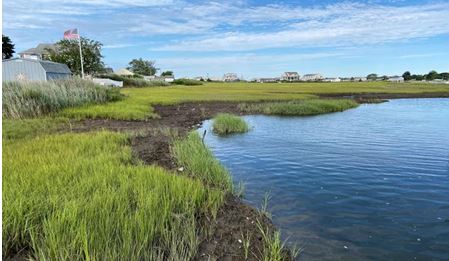
The Back River Living Shoreline project includes the Conceptual Design (60% Plan Set) of proposed marsh shoreline stabilization and ecological restoration along an approximately 350-foot section along the south bank of the Back River within the Plum Bank Wildlife Marsh Area in Old Saybrook, Connecticut, using Natural and Nature-Based Features (NNBFs).
Product
Back River Living Shoreline Marsh Shoreline Stabilization Project
Back River Living Shoreline Conceptual Design
May, 2023
Project Description
This project was performed as part of the CIRCA Municipal Resilience Grant Program (MRGP) Application, “Back River Living Shoreline”. This section of the Back River riverbank has been experiencing on-going and significant shoreline erosion since 1934, the year the existing Route 154 Bridge 01386 was constructed. Back River is a natural tidal marsh channel, hydraulically connecting marsh to Long Island Sound. Upstream and downstream of Bridge 01386, Back River bends sharply to the north and continues to meander throughout the marsh. The existing bridge (and proposed bridge replacement) restrain the natural meander of the channel and also constrain flow, resulting in high velocity channel and bank flow, eddies and whirlpools. This, possibly with other factors, appears to be contributing to significant erosion of bank edges, loss of marsh area, and deep channel scour holes. Significant shoreline erosion and marsh loss has specifically occurred within the area immediately west of the bridge, including the south bank of the Back River. Scour holes are located within the channel and are deep (as deep as elevation -28 feet NAVD88). These adverse impacts to coastal resources are expected to continue in the future. The observed shoreline erosion is expected to continue, resulting in on-going and significant loss of marsh. Therefore, shoreline stabilization is warranted. The channel flow velocities (which are artificially due to the bridge hydraulics) and associated shear stresses are too high to warrant shoreline stabilization using only natural vegetative materials. The proposed shoreline protection alternative is a hybrid solution that integrates a rock rip-rap revetment with sand fill, planting and mixed oyster bags/clutches and mussels and revegetation with spartina alterniflora and spartina patens. The proposed construction is to be performed from the landside, requiring construction vehicle access over the existing High Marsh using timber mats. The project will require work seaward of the High Tide (HAT) line and the Coastal Jurisdiction Line (CJL). Details of the prosed project and an estimate of probable construction cost is presented in the report. Post-construction monitoring with maintenance is recommended. The proposed shoreline stabilization utilizes natural materials and rock armor. As a nature-based system, the proposed shoreline stabilization should be considered experimental and the long-term performance is uncertain. Also, the on-going hydraulic effects of the existing bridge (and proposed bridge) will continue to create high velocity channel flow resulting in high shear stresses on the channel bank and bottom. The existing channel scour hole appears to be advancing toward the south bank of the river, destabilizing the bank sediment. Sea level rise is expected to increase this risk. The proposed shoreline stabilization includes the use of crushed stone mattresses for the purpose of minimizing bank destabilization; however, significant advancement of the scour hole may eventually cause destabilization of the improved shoreline (as well as the existing boat ramp and pilesupported docks).
Project Team
Town of Old Saybrook
GZA GeoEnvironmental, Inc.
UConn CIRCA
Topic Areas
This project is a part of the following topical areas: